Crop Forecasting
Crop forecasting is essential for agricultural planning and management. Accurate crop forecasting enables Government, policymakers, and the agribusiness sector to make informed decisions about crop production, distribution, and marketing. Crop forecasts help to prevent food shortages and price volatility by allowing for timely interventions such as adjusting trade policies, food aid programs, and early warning systems. Accurate crop forecasting is also crucial for farmers to optimize their crop management practices to adjust planting strategies, and to ensure that the right inputs such as water and fertilizer are applied at the right time. Overall crop forecasting helps to ensure food security and economic stability in agricultural communities. Remote sensing is a powerful technology that has been increasingly used in agriculture for crop forecasting. By analyzing the spectral characteristics of crops using satellite imagery, remote sensing allows farmers and researchers to estimate crop yields and predict potential crop losses due to factors such as pests, disease, and weather events. Remote sensing can also provide information about soil moisture levels, plant health, and growth rates, which can help farmers make more informed decisions about irrigation, fertilizer application, and other management practices. By integrating remote sensing with other data sources such as weather forecasts and crop models, farmers can make better-informed decisions that can improve crop yields, reduce input costs, and minimize risks.
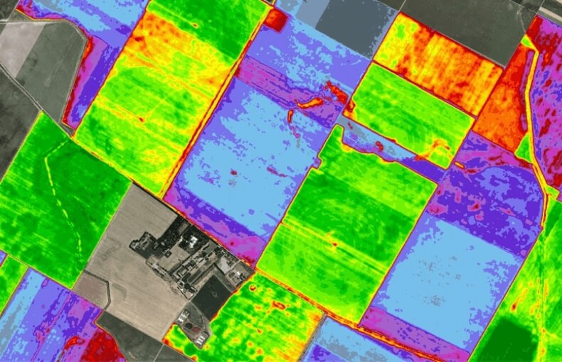
We have utilized the random forest machine learning algorithm to classify major Kharif, rabi and summer crops in North Gujarat from 2018 cropping season onwards using time-series Sentinel-2 optical data. We have also classified Rabi season crop in Haryana in India as well as Sugarcane in Zambia and Tanzania in Africa. In Saskatchewan, Canada various crops were also classified using the same methodology. The algorithm was used to identify and distinguish between different types of crops such as wheat, castor, potato, rice, fodder, maize, sugarcane etc with an accuracy of over 85%. This approach has the potential to improve crop mapping and monitoring, ultimately supporting more efficient agricultural practices and better food security in these regions. Estimated acreage are also being used to estimate crop production by multiplying the average yield per hectare for a given crop by the estimated acreage planted.